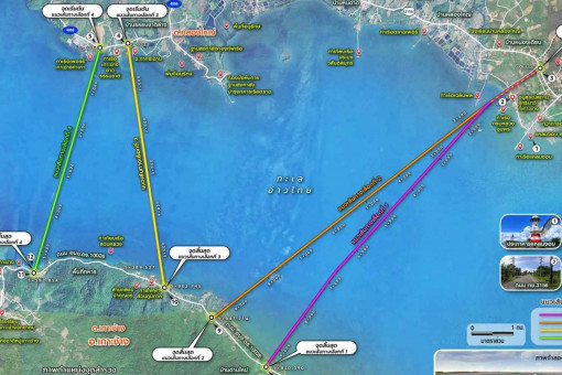
Four proposed routes under consideration

The Expressway Authority of Thailand (Exat) has started public hearings on four optional routes for the proposed bridge from the mainland to Trat’s popular Koh Chang island.
Exat deputy governor Katpachon Udomthampakdee said there were four bridge options. They involved three possible locations on the mainland in Trat and four on the island – three in Ban Dan Mai and one in Ban Khlong Son.
The first two options would both start at the 0.85 kilometre marker on Highway 3156 in Ban Nong Prue village of Laem Ngop district.
One would be 9.82 kilometres long and reach the island at the 8.55 kilometre marker on Road 10026 in Ban Dan Mai.
The second would be 9.95km long and reach the island at the 6.75 kilometre marker on Road 10026, also in Ban Dan Mai.
The third, 5.90km long, would start at the 2.84 kilometre marker on Road 4006 in Ban Thammachat Lang of Laem Ngop district and reach the island at the 5.30 kilometre marker on Road 10026 in Ban Dan Mai
The fourth route, 5.59km long, would start at the 3.50 kilometre marker on Road 4006 in Ban Thammachat Lang and reach the island at the 1.90 kilometre marker on Road 10026 in Ban Khlong Son.
The four bridge options would all be elevated and high enough to give ample clearance for shipping, and land on the island in thinly populated locations. The bridge would not affect the coral and seagrass near the island.
Construction of the new bridge is planned to begin in 2029, with the opening in 2033.

